Shoal Creek in Austin, TX frequently experiences high water flows during heavy rain events.
The creek's water levels are measured at a 20 ft high and 112 ft wide bridge just upstream from bridges between 8-14 ft in height and 68-105 ft in width at points where the creek narrows.
This site explores hydrology and safety.

To obtain a verified answer as to why low lying and narrow bridges along Shoal Creek don't experience routine overtopping.

The only exact way to understand how a seemingly greater volume of water than can fit through a constricted opening manages to do so would be to have a water gauge positioned at every bridge. That is obviously unfeasible.
Water models and potential variables that could explain how 11.5 feet of fast-moving water, recorded at a bridge that is 17 feet high and 120 feet wide, can pass through a heavily congested bridge that is approximately 9 feet high and 110 feet wide cannot provide a reliable or sufficient answer.
The force with which water passes through the partially blocked W. 5th St bridge, and other smaller bridges, is the best available indicator of how the extraordinary volume of floodwater that Shoal Creek receives is conveyed beneath and through its undersized bridges.
Floodwater at W 5th St does not appear to move rapidly, as shown in the live video available on this site.

To determine at what point gravel bars (moguls of rock) under a bridge are deemed to be (i) an overtopping hazard and (ii) a fire hazard, as they have repeatedly enabled people to camp and build fires in direct proximity to utility infrastructure.
Despite repeated attempts, engineers with the City's Transportation and Watershed departments could not provide an answer as to when blockage beneath a bridge becomes a structural and/or functional concern.
An inspection of Shoal Creek with engineers from the Watershed Department was scheduled for April 2026 but was canceled due to weather and never rescheduled. Unfortunately, no engineers participated in the field inspection conducted on 07/17/2026.
The Shoal Creek Conservancy declined to comment on the contents of this website and chose not to participate in this investigation, instead directing all concerns to the City's Watershed Department.
A dated study conducted along Shoal Creek concluded that sediment did not need to be removed from the creek because its impact on water levels was negligible (approximately 1–3 inches). However, the study stated that the areas around W 6th St and W 5th St should continue to be monitored pursuant to an agreement between the condominium owners and the City.
The study did not address the gravel bars beneath the W. 5th St. bridge.
It can be reasonably assumed that removing the gravel beneath the W 5th St bridge would only result in gravel deposits returning over time; such accumulation is a natural process requiring ongoing maintenance.
During a discussion with a City engineer regarding the structural implications of a bridge with approximately 30% of its arch openings obstructed by gravel, I was informed that bridge inspections are performed by TxDOT.
While TxDOT inspects every bridge in Texas—more than 60,000 structures—on a two-year cycle, the performance, appearance, and maintenance of bridges within Austin’s jurisdiction remain the responsibility of the City.
TxDOT routinely removes sediment and debris from bridges located in floodplains under its jurisdiction to preserve hydraulic capacity and ensure that bridge openings continue to function as intended by their original design.
A fire beneath the W 5th St bridge in April 2026 caused extensive damage to utility infrastructure, requiring approximately two months to repair at significant cost. According to an Austin Energy technician present during the field inspection on 07/17/2026, fiber-optic infrastructure in the area costs approximately $80,000 per 400 feet.
Suggesting that people start fires beneath all kinds of bridges is a false equivalence in this context.
The W 5th St bridge is exceptionally low in height and carries an array of telecommunications and water infrastructure beneath it. The bridge's limited clearance, coupled with the 3- to 4-foot rise in ground elevation created by the gravel bars, allows fires to be built much closer to utility lines than would be possible beneath bridges with greater clearance.
Based on a site inspection, it appears that if the ground beneath the W 5th St bridge were at the natural creek-bed elevation and remained consistently wet, the likelihood of fires being started beneath the bridge would be considerably reduced.

To determine if an exposed water utility pipe requires additional protection from potential debris strikes during flooding.
The pipe is designed to take considerable impacts.
The concern here was born from impact damage sustained by less sturdy pipes spanning under the W 5th St bridge (Utility Pipe Damage From Debris Strike @ W 5th St) during flooding and the fact that water kisses the West Ave bridge pipe during flooding (West Ave Bridge Area Debris Strike Damage).

Walking the creek from W 12th St down to Lady Bird Lake, there is only one sign warning people of the hazards of flash flooding within this federally designated floodplain, which falls under the jurisdiction of the municipality.
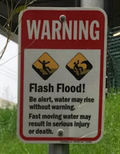
Consideration should be given to installing warning signs at all entrance points along the Shoal Creek pathway, warning users of the dangers posed by flash flooding and explaining that the creek's water level can rise several feet within minutes as a result of heavy rainfall occurring upstream, even when local weather conditions appear calm.
Austin has many tourists and new residents unfamiliar with the weather conditions here. Most people associate dangerous flood waters running through an urban environment with extreme weather like hurricanes. The water surges that Shoal Creek experieinces can be startling to many people unfamiliar with the fact that Austin is nicknamed "Flashflood Alley."
Signs posted at entrances to the Shoal Creek pathway that include photographs of flood conditions along Shoal Creek, along with examples of circumstances in which the pathway should be avoided, would better inform the public of the associated risks. While flash flood warning systems complement physical signage, not everyone carries a cellphone at all times or receives emergency alerts.
A special thank you goes to the Director and staff of the USGS Oklahoma–Texas Water Science Center, as well as the Director of Engineering and Safety Operations and staff of the Texas Department of Transportation, for arranging timely, straightforward, and informative answers to questions related to their complex work.
Disclaimer: All measurements on this website are approximate.
Copyright © 2026 austinshoalcreek.com - All Rights Reserved.

To cap off the purpose of this website: Three utility technicians, two hydrologists, one Municipal Policy Advisory Committee member, and a guy known for carrying a flip phone set out to answer two questions: How can water that rises higher than a bridge pass beneath it, and was removing mounds of rock beneath Austin's W. 5th St. bridge actually necessary?